
This is an appendix to: Huser et al. 2023. Handbook – a decision-support tool for measures against internal phosphorus loading in lakes.
Download pdf-version of appendix 5
Purpose
This document describes how bathymetric maps can be used to calculate water volumes for distinct depth intervals.
Background
To quantify the internal load in terms of the amount of phosphorus released from, the phosphorus concentration measured needs to be multiplied by the water volume. For fully mixed lakes, the concentration is constant with depth and the amount is readily calculated by multiplying the phosphorus concentration with the water volume of the entire lake.
For dimictic and partially stratified polymictic lakes, it is necessary to divide the lake into different depth intervals as the phosphorus concentration may change rapidly with depth. This is best to do at one metre intervals. To calculate the amount of phosphorus, it is first necessary to calculate the water volume for each depth interval. This is done using the lake’s bathymetric map.
Bathymetric maps
In Sweden there is no national data host which collects bathymetric maps for all Swedish lakes. However, SMHI provides an Excel file through its SVAR-service that includes data on surface areas and volumes for about one thousand lakes.[1] These data may be sufficient when calculating internal loading in shallow, completely mixed lakes, but bathymetric maps are needed for dimictic and polymictic lakes. SMHI’s dam and lake register[2] provides bathymetric maps for a small number of lakes, but in many cases it will be necessary to create a bathymetric map.
Bathymetric maps are produced by using a device to measure depths across a lake. Manual sounding using a plumb and manual recording of the water depth at various locations in the lake was the main method used in the past. The bathymetric map is then created by drawing isolines through locations with the same depth.
Nowadays, some form of sonar is commonly used for depth sounding and production of bathymetric maps. These bathymetric maps usually have a much higher resolution than bathymetric maps produced by means of manual sounding. Sonar data can usually be imported into GIS or other programs that can be used to produce bathymetric maps and calculate water volumes for both the entire lake and for different depth ranges.
Bathymetric maps that are only available on paper or in PDF format need to be digitalised. The digitalised maps can then be imported into GIS software in order to calculate the water surface area for each isoline. It is also possible to calculate water volumes for different depth intervals in many GIS programs. Contact your GIS coordinator or consultant for help with this.
There is currently no national guidance on how to produce bathymetric maps, but the service is provided by several consultants. You may wish to use the Swedish University of Agricultural Sciences’ specifications for sounding and bathymetric mapping of trend lakes (Swedish University of Agricultural Sciences, Department of Aquatic Resources) as a basis when procuring the service.
Calculation of water volume
The calculation method below does not need to be used if bathymetric mapping has been carried out by means of sonar. This is because GIS or similar programs can use all the data from the sonar to calculate water volumes with high precision. Such programs can be used to calculate water volumes for any depth interval. However, areas and depth intervals in shapefiles made using GIS software can also be used with the method below.
The calculation method below can be used if you only have access to older bathymetric maps with low resolution, or only information on the area between isolines.
When calculating the water volume for different depth intervals, it is important to work on the basis of the accumulated (total) area of each depth interval and not the (partial) area of the depth interval. In the illustration below (Figure 1), a0 represents the total area of the lake, a1 the total area at depth 1, etc. The area of a depth range, often referred to as the subarea, is the difference between the total area at two depths. For example, the subarea of the depth range d0 and d1 is the difference between a0 and a1.
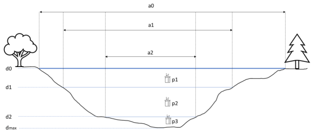
The water volume for different depth intervals can be calculated simply as the average of the total area of the upper and lower depths of a depth interval multiplied by the extent of the depth interval. For example, the water volume for the depth range d1-d2 is calculated as

where area is given in m2 and depth in m.
This is a simplified method of calculation, because by taking an average for the area of the depth range ((a1+a2)/2) the model assumes that the lakebed is inclined at a 45° angle, which is rarely the case. This calculation method is mainly used when only older, low-resolution bathymetric maps are available.
Instead of calculating an average for the area of the depth range, it is possible to create a hypsograph; and the area at different depths can be calculated by means of interpolation by establishing a link between the depth of the lake and its area. This method has the advantage of using all available bathymetric mapping data but relies on the assumption that there is a relationship between lake depth and area. The method can also be used to calculate water volumes for depth ranges other than those for the isolines.
[1] SMHI, SVAR (Swedish Water Archive). Database containing a collection of bathymetric maps with data on lake depth and volume. https://www.smhi.se/data/hydrologi/svenskt-vattenarkiv
[2] SMHI and the Swedish Agency for Marine and Water Management. Dam and lake register. https://vattenwebb.smhi.se/svarwebb/